Grand Avenue Field Notes
King Mountain gliding near Arco: the launch, the airfield, and what visitors should know
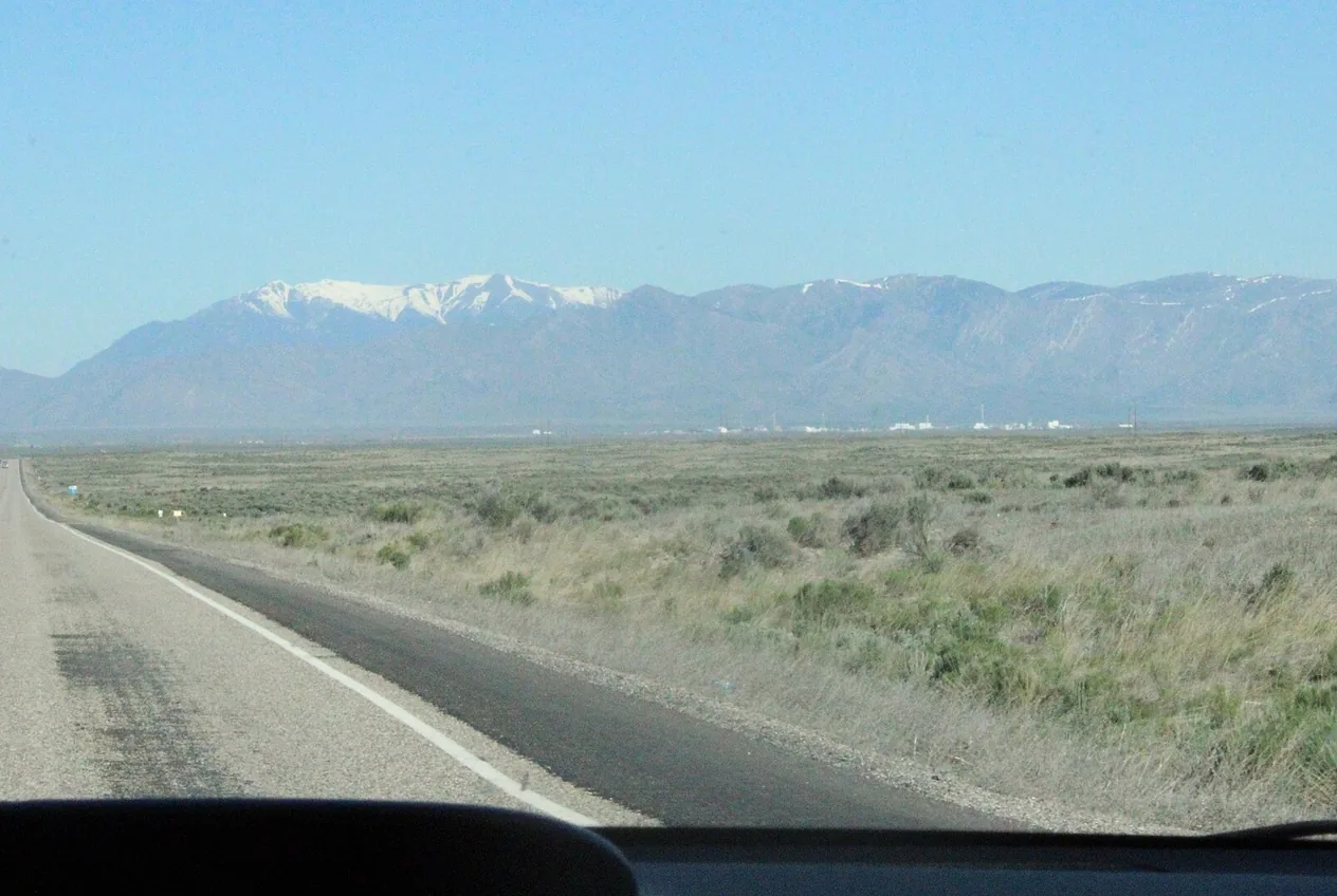
King Mountain, north of Arco near the small town of Moore, is one of the few places in Idaho where you can legitimately see hang gliders, paragliders and sailplanes sharing the same sky. It earns that reputation from a high, dry valley that heats up hard under the Idaho sun and a ring of mountain ranges that shape the wind. It also earns a reputation for being demanding: the Forest Service rates the mountain launch H4/P4, which is advanced territory, and the airfield in the valley below is private-use aviation property rather than a roadside attraction.
Jump to trip essentials- Region
- Moore, Idaho
- Season
- Late spring through early fall; weather dependent
- Category
- Gliding
Before you go
- Two different destinations: the Forest Service mountain launch, and the separate private-use King Mountain Glider Park airfield.
- Advanced H4/P4 hang gliding and paragliding site — not a beginner hill, a tandem booking service or a scheduled airshow.
- No restroom, no potable water, no fee and no reservations at the Forest Service launch.
- The gliderport is private use: permission required before landing, unattended, no control tower, no winter maintenance.
- Never enter a launch path, landing area or runway, and keep drones grounded while gliders are flying.
Official launch site
Forest Service King Mountain Launch Site near Moore, reached from US-93 at the hang glider signs and up toward Beaverland Pass Road. This pin marks the mountain launch only — it is not the King Mountain Glider Park airfield.
View on OpenStreetMapKing Mountain at a glance
What it is: an advanced mountain launch site for hang gliders and paragliders in the Salmon–Challis National Forest, above a valley that also supports sailplane flying from a nearby private airfield. Where it is: north of Arco, near Moore, on the western side of the Lost River Valley, reached off US-93. Who manages the launch: the Salmon–Challis National Forest, which lists it as an advanced H4/P4 site with no fee and no reservation system.
What it is not: a beginner training hill, a tandem-flight booking desk, an aircraft rental counter, a staffed flight school, a commercial scenic-flight operator, or a place where aircraft are guaranteed to appear on any given day. None of those services are offered at the Forest Service launch, and the valley airfield is private-use property that requires permission before landing.
For qualified pilots, King Mountain offers genuinely strong soaring in country that few flying sites in the Intermountain West can match for scale and emptiness. For everyone else it offers scenery, small-town Idaho history, and the chance to observe a serious aviation community from a safe distance — provided you arrive expecting a landscape rather than a performance, and you stay out of launch paths, landing areas and runways.
Two places, two owners, one name problem
The single most useful thing to understand before you set out is that “King Mountain” means two different destinations that sit several miles apart and answer to completely different authorities. Getting them mixed up is the most common visitor mistake, and navigation apps make it easy.
The first is the King Mountain Launch Site: a Forest Service recreation location in the Salmon–Challis National Forest, high on the slope, with a lower launch that has a picnic table and a windsock and an upper launch with a metal ramp. This is where hang gliders and paragliders foot-launch. It has no restroom, no potable water, no fee and no reservation system, and the Forest Service publishes its coordinates as approximately 43.768667 latitude, -113.289059 longitude.
The second is King Mountain Glider Park: a private-use gliderport in the valley near Moore, listed at 3237 W 3400 N in Moore, with FAA identifier ID36. It is an airfield with a turf runway, and it is where sailplanes operate. Published aeronautical information marks it private use, requiring permission before landing, unattended, with no control tower. Its own supporting organisation, the King Mountain Glider Park Foundation Inc., describes itself as a 501c3 dedicated to supporting free flying in the Lost River Valley.
A third name sometimes turns up in local use: King Mountain Natural Arch, a rock formation in the same broader area. It is neither the launch nor the airfield.
The practical rule is to decide which destination you actually mean before you put anything into a sat-nav, and to treat the pin on this page as the Forest Service launch — the place a visitor is most likely to drive toward. Do not assume one pin represents both sites.
Why this particular valley produces lift
Soaring depends on finding rising air and staying in it. The Lost River Valley is unusually good at producing it, for reasons that are visible from the road if you know what you are looking at.
The country here is high and semi-arid, with less than ten inches of annual precipitation according to the soaring community’s own weather resources. Dry ground with sparse vegetation heats efficiently, and it does so unevenly — a sun-baked slope of dark rock warms faster than a valley floor of pale sediment or an irrigated field. That uneven heating peels off columns and pockets of warm air: thermals. A pilot climbs in one thermal, glides across toward the next while slowly losing height, finds it, climbs again. That cycle is what lets an unpowered aircraft cover dozens of miles.
The mountains do the second job. Air forced to flow around and over a range gets deflected upward along the windward slope, which is ridge lift, and under the right stability conditions the atmosphere downstream of the barrier can set up standing waves — smooth, powerful rising air on the upwind face and often lenticular clouds marking the crests. Pilots who have been waiting all year for a wave day take notice when the forecast calls for strong flow over the Lost Rivers.
The same terrain that creates lift also creates the danger. The Forest Service’s own site description warns that several passes and gaps exist in the Big Lost River Mountain range to the north that will compress and multiply the existing wind speed. Air squeezed through a gap accelerates. A wind that feels moderate and manageable down in Moore can be something else entirely at a launch sitting above and to the side of those gaps.
The local soaring weather guidance describes the seasonal rhythm too. Spring brings cold nights followed by hard daytime heating, which produces strong, abrupt thermals, and Pacific fronts that can move through on intervals of roughly twenty-four to forty-eight hours, with cloud bases of twelve to fourteen thousand feet not uncommon under some spring patterns. Summer heat can push afternoon temperatures into the 90s Fahrenheit and, when monsoonal moisture arrives, bring thunderstorms and gusty outflow that are absolutely not flying weather. Same valley, completely different day.

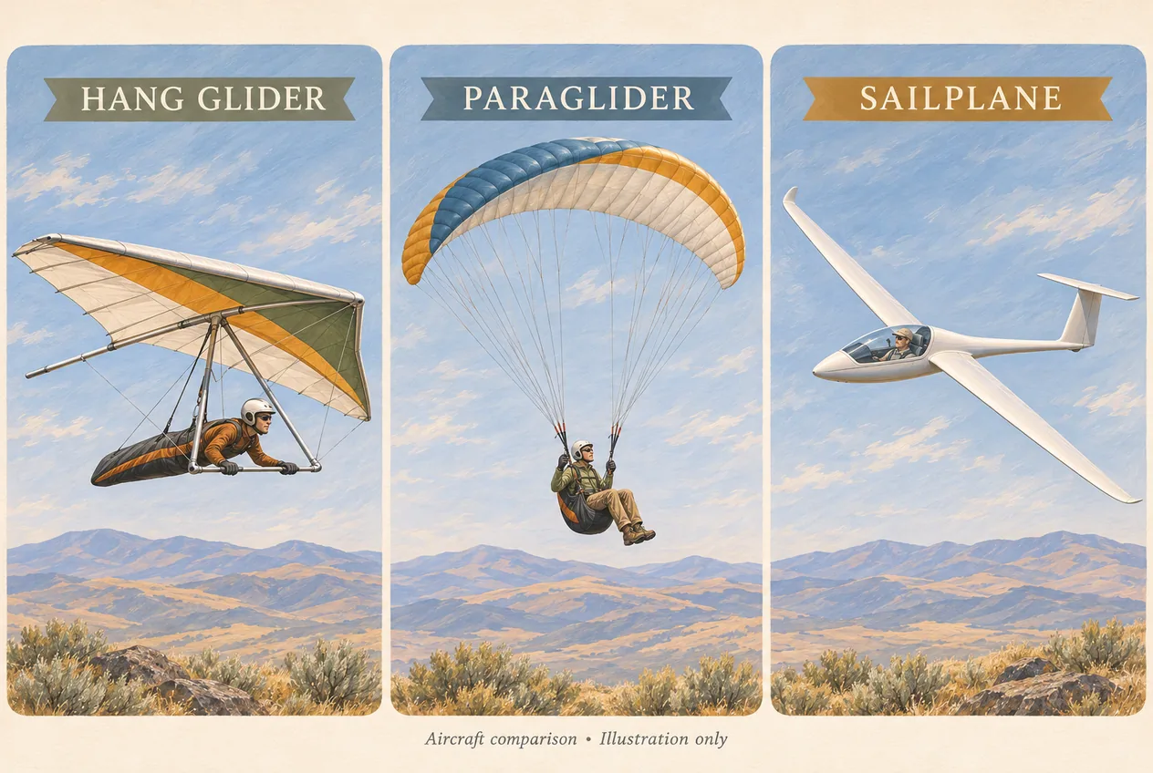
Hang glider, paraglider, sailplane: three aircraft, one sky
People who stop to watch usually assume they are all “the same glider thing.” They are not, and the differences explain a lot about who is allowed to fly where.
A hang glider is a framed, triangular wing — aluminium or composite tubing with a flying surface stretched across it. The pilot is suspended below it, usually prone, and controls the aircraft by shifting weight relative to the control frame. It launches on foot off a slope or a ramp. The wing has real structural character: long spans, sharp corners, and a pilot hanging underneath with a good view in every direction.
A paraglider has no rigid wing at all. It is a fabric canopy that holds its airfoil shape from ram air pressure, connected to the pilot’s seated harness by long, fine suspension lines. Steering comes from brake toggles plus weight shift. It packs down small enough to carry on foot, which makes it portable in a way a hang glider never is — but portability is emphatically not the same as being easier or safer. A paraglider is extremely sensitive to turbulence, wind gradient, rotor and sudden changes in air movement, and its lines can lie across a wide area almost invisibly while a pilot is setting up.
A sailplane — the rigid-wing gliding aircraft people often cannot name — is a purpose-built fixed-wing aeroplane with long, narrow, high-efficiency wings and a pilot sitting inside an enclosed cockpit. It does not foot-launch. It takes off from an airfield, normally under aerotow behind a tow plane or launched by winch, and is released to fly. Sailplanes are remarkably clean aerodynamically, so a pilot can stay airborne for hours and travel long distances whenever usable lift keeps appearing.
At King Mountain the split roughly follows the terrain: hang gliders and paragliders use mountain launches, sailplanes operate from the valley airfield. But the flying community here deliberately mixes them. The glider park’s own banner is “All Birds are Welcome,” and its gatherings bring all three together over the same valley, which is precisely why traffic awareness matters so much. Wings of very different span, speed, turn radius and visibility are working the same airspace, and one of them can be almost silent.
Worth saying plainly: an engine is not what makes aviation complex. Launch judgment, thermal management, airspace awareness, landing-area selection and weather interpretation are the hard parts, and an unpowered pilot has none of the options a powered pilot has when a plan goes wrong.
What the H4/P4 rating actually means
The Forest Service lists King Mountain as an advanced hang gliding and paragliding site, rated H4 for hang gliders and P4 for paragliders, and names three hazards directly: strong thermal conditions, moderate turbulence, and occasional high winds that develop quickly. It also flags the gap-wind effect from the Big Lost River range and adds a specific instruction that first-time pilots should contact a local pilot familiar with the area before flying here.
Treat that rating as a site qualification, not as a suggestion. The rating is about whether a pilot has demonstrated the judgment and proficiency the site demands, which is a different question from whether they are physically capable of launching an aircraft from a ramp. Plenty of pilots hold a rating that nominally meets a site’s class and would still make a poor decision on a King Mountain afternoon.
In practice the rating means a competent pilot arriving here for the first time should expect the following: thermals strong enough to require active management rather than passive riding; mechanical turbulence off the terrain, especially downwind of ridges and in the lee of the launch itself; wind that can strengthen well past anything the valley suggested; the possibility of being carried out beyond easy return if a downwind situation develops; and landing options that are constrained by private farmland, irrigation equipment, fences, livestock and power lines rather than by an open public field.
It is also worth understanding that the rating is a floor and not a ceiling on the day. A site can be rated H4/P4 and still be, on a specific afternoon, beyond what a well-qualified pilot should attempt. That is not a contradiction. It is why the correct decision at King Mountain is sometimes to unpack nothing, sit in the grass and watch, and drive back down.
What you cannot do here
This section exists because the expectation gap around King Mountain is large and expensive to close after the fact. Here is what the site does not offer, stated as directly as possible.
You cannot arrive and book a first flight. The Forest Service launch is not a tandem operation, not a rental counter and not a flight school, and there is no desk at the top of a Forest road where a visitor can pay to go up. The glider park is a private-use aviation facility, not a place to walk onto the apron and ask for a ride.
You cannot treat the launch as a spectator platform. Launch and landing areas are active operational spaces. Pilots setting up a wing are busy with equipment, checks and wind assessment, and a visitor wandering into that space is a hazard to themselves and to the pilot.
You cannot assume anything is happening. Flight activity depends on weather, pilot availability, road access and whether an organised event is scheduled. A no-fly day is common and is itself evidence the place is being run sensibly.
You cannot land there. Published aeronautical information for ID36 marks the field private use with permission required before landing, and it warns that an open-looking agricultural field is not automatically available — irrigation equipment, crops, fencing, livestock, power lines and private ownership all make clear-looking fields unsuitable.
You should not fly a drone here. If gliding operations are underway, keep the drone on the ground. A small drone is genuinely difficult for a glider pilot to see against a bright sky or a hillside, closing speeds are high, and an unpowered pilot cannot add power and climb out of a conflict. Do not assume flying low and “below the traffic” is safe: gliders descend toward landing areas and sailplanes make deliberately low approaches.
If Club Sawtooth ever promotes a lesson, tandem flight or orientation ride in this area, that would be a specific commercial arrangement with a named, currently qualified and insured operator — verified at the time, not inferred from the existence of a flying site. Today we publish none.
King Mountain Glider Park: what the airfield is
The airfield deserves its own section because it is where the sailplanes live, and because visitors are most likely to trespass there by accident.
Published facility information identifies ID36 as a private-use gliderport roughly two miles northeast of Moore at an elevation in the region of 5,500 feet, with a turf runway designated 16/34 in the neighbourhood of 3,900 feet long and 120 feet wide, a wind indicator, a segmented circle and tiedown availability. There is no control tower, the field is unattended, and CTAF 122.9 is the published common traffic frequency. The printed remarks include use at own risk, the possibility of irrigation equipment on or adjoining the runway, a tall centre-pivot irrigation system south of the runway, numerous hang glider, paraglider and sailplane operations in the area, and no winter maintenance.
Read those remarks the way a pilot does. “Irrigation equipment may be on or adjoining the runway” means the ground around the surface has metal in it that was not there last season. “No winter maintenance” means nobody ploughs, so a map listing in March tells you almost nothing. “Numerous hang glider, paraglider and sailplane operations” means aircraft of every description may cross your path without any controller coordinating them.
The behavioural rules follow simply. Do not cross or drive onto the runway. Do not walk into aircraft operating areas. Do not enter the property expecting services: published sources do not list fuel, aircraft repair or oxygen at the field, and an unattended field is not a staffed fixed-base operation. Anyone who genuinely needs to be there — a pilot, a tow pilot, a crew member, a journalist, a landowner’s guest — coordinates in advance through the organisation rather than arriving and asking.
One more thing the site is worth knowing about, because it explains the tone of the whole place: the glider park is supported by a foundation that asks for donations to keep free flying alive in the valley. This is an amateur aviation community that built and maintains its own infrastructure, including its own named launches and landing zones, in a remote valley because they want the flying to exist. That is a good reason to be courteous about it.
How to watch gliders without being a hazard
Watching is a legitimate and enjoyable thing to do here, and it can be done properly. The requirements are spatial awareness and patience.
At the mountain launch, stay behind pilots who are preparing to launch, never downhill of a launching pilot under any circumstances, and keep clear of wings, control frames and suspension lines. Paraglider lines in particular can extend across a wide area and are hard to see; stepping on one can damage a line or disturb a launch sequence, and neither ends well. Do not distract pilots during setup or pre-flight checks, keep children and dogs secured and with you, do not kick up dust near laid-out equipment, never touch an aircraft without permission, keep drones grounded, and follow any instruction given by a pilot on site.
At or near the airfield, the runway is the boundary that matters. Even an unattended field is an active airfield. Watch for aircraft on final approach, for sailplanes that are nearly silent, for tow planes with long lines of rope behind them, for ground vehicles, for wings extending far beyond what you assumed the aircraft’s outline was, and for irrigation pipe sitting near the surface. The absence of engine noise does not mean the runway is clear — it may mean something efficient is already overhead.
Where to stand: at the launch, position yourself where you can see the sky and the pilot’s back, well clear of the slope below the ramp, and where a pilot who has launched will never have to fly toward you. Give retrieval vehicles room on narrow Forest roads; drivers returning from a landing site have a right-of-way problem you cannot see from the shoulder.
And hold your expectations loosely. If nothing launches, nothing launches. Photograph the valley, enjoy the emptiness, and come down. Nobody on the mountain resents a visitor who parked sensibly and stayed out of the way — and a visitor who wandered into a launch path is a different conversation entirely.
If you are a pilot: what a first King Mountain flight involves
This is not a flight-planning guide, and nothing here substitutes for your own qualifications, aircraft condition, current aviation weather, airspace rules and personal go/no-go judgment. What follows is the shape of the planning a first-time King Mountain pilot should expect to do.
Start with local site knowledge, which the Forest Service asks for explicitly. A pilot rating establishes general proficiency; it does not orient you to this mountain. Local knowledge covers launch-specific wind behaviour, where terrain-induced turbulence actually sits, which areas are affected by rotor, which landing zones are normal and which look fine but are private or restricted, how valley wind develops through the day, road conditions, radio practice, retrieval expectations and any current site concern. Ask before you go, not after you land in a bean field.
Evaluate mountain weather, not valley weather. A forecast for Arco or Moore does not describe conditions at launch altitude. The working list includes surface observations, winds aloft, stability, thermal and convective outlooks, thunderstorm probability and gust-front potential, cloud base, frontal timing, wind direction at several elevations, mountain-wave potential, density altitude, and how much daylight is left for retrieval. The glider park maintains weather resources specific to soaring here; combine them with official aviation weather and your own eyes.
Establish the landing plan before launch. Know where a legal and suitable landing exists for every plausible failure of the plan, and know what is not available. Then plan retrieval seriously, because cross-country soaring routinely ends far from the launch: driver coordination, road access limits, offline maps, fuel, radio frequencies, the reality of thin cellular coverage in this country, and for longer flights the tracking and check-in discipline that the glider park recommends for its own organised events.
Inspect the aircraft completely, following manufacturer procedures and your governing association or aviation requirements — sail or canopy, structure, battens, cables and attachment points, lines and risers, harness connections, reserve, instruments, radio, tow releases, control surfaces, tyres and tow gear. A remote mountain launch with no services and a long drive out is the wrong place to discover a missing pin.
Take altitude seriously. King Mountain flying can reach physiologically meaningful height quickly, particularly at an already-elevated site, and hypoxia, dehydration, cold, fatigue and impaired night vision all degrade judgment before a pilot notices it happening. A strong thermal offering another thousand feet is not automatically a reason to take it.
Driving up: the road is part of the risk assessment
The Forest Service directs visitors to the launch from US Highway 93 at Moore: from Mackay, take Highway 93 south about fifteen miles to Moore, turn left at the hang glider signs, and follow them to the launch sites on Beaverland Pass Road. Directions that start from the north sound simple and are not a guarantee about the surface.
Forest roads in this country change. Gravel becomes washout, washout becomes mud, mud becomes a snowbank in June, and fire restrictions or seasonal closures can put a gate across a route that was open last month. Before driving up: check current Forest Service notices for the Salmon–Challis, look at the agency’s official maps and its Motor Vehicle Use Maps for the area, confirm the specific road you intend is open, judge whether your vehicle has the clearance it needs, carry a spare tyre and reasonable recovery equipment, top up fuel before leaving town, bring more drinking water than you think you need, and leave yourself enough daylight to come back down slowly.
Two things never to do: drive around a closed gate, and cut a new route around a washout. Both turn a recreation problem into a legal and ecological one, and both are visible from the air to the people who manage this land.
A route appearing in a consumer navigation application proves that someone once drove it. It does not prove the route is open, maintained, legal for your vehicle or suitable for your vehicle. Where the Forest Service publishes digital maps, an interactive visitor map and Motor Vehicle Use Maps, those are the documents to trust over an app.
Facilities, fees and when to come
Facilities at the Forest Service launch are minimal by design. There is a picnic table and a windsock at the lower launch and a metal ramp at the upper launch. There is no restroom. There is no potable water. There is no reservation system and, per the Forest Service listing, no fee at this location. Bring everything you need for the day, including all drinking water, and pack out every item you carried in.
The airfield offers a turf runway and published tiedown information but should not be assumed to provide fuel, maintenance, oxygen or staffing, and it receives no winter maintenance.
Season by season, the pattern is roughly this. Late spring can produce the strongest, most abrupt flying, with snow still on the surrounding ranges and fronts arriving every day or two — and snow or mud on the access road even when the valley looks mild. Summer gives long daylight and strong heating, with afternoon highs commonly in the 80s and sometimes the 90s, plus the thunderstorm and gust-front risk that goes with monsoonal moisture. Late summer and early fall have historically been when organised soaring gatherings happen here, and remain excellent flying months with cooler mornings. Winter limits mountain access, runway usability and everything else with snow, ice and cold.
Whatever the month, the honest answer to “when should we go” is: go when conditions and road access allow, and treat the flying as a bonus rather than the plan.
The King Mountain Glider Safari
The glider park has long hosted a gathering known as the King Mountain Glider Safari, which brings sailplane, hang glider and paraglider pilots together for soaring and community events. The park’s own archive records Safaris going back to an inaugural event in 2009, with gatherings listed across the years since. Past events have promoted free camping at the glider park and have strongly recommended satellite-based flight tracking for participants.
An event like this is the best chance a non-pilot has to see a lot of aircraft in the air at once, and the worst chance to find anywhere to park. If you plan a visit around an organised gathering, get the current details first: dates, camping availability, participation requirements and visitor access all change, and an event page from a previous year tells you nothing reliable about this one. Check the park’s official events page rather than assuming the Safari falls on the same dates every year.
We deliberately do not print a specific year’s schedule in a guide like this one. Anything dated goes stale, and a stale event page is how visitors turn up on the wrong weekend in a town with no hotel to spare.
A no-fly day is still a good day
If nothing is airborne when you arrive, you have not wasted the trip — you have arrived on a normal day at a mountain flying site, and there is plenty else in the same direction.
The Forest Service describes the wider Arco Pass area as encompassing both the King Mountain Launch Site and King Mountain Natural Arch, and lists opportunities including day hiking, picnicking, scenery and wildlife viewing, scenic driving, horseback riding, camping, off-highway-vehicle use and winter recreation. Its launch listing itself associates hiking, day hikes, picnicking, hang gliding and viewing with the site. That is a genuinely full day without an aircraft in the sky.
None of that means every road or trail is open to every use, and it emphatically does not mean the launch access road is an OHV route. Route designations and seasonal access need confirming with current Forest Service maps and on-site signs before you commit to them. If you want a documented walking day instead of an exploratory one, the hiking around Arco and the Craters of the Moon area is better signed and better suited to a family.
For a short list of things that work on a flat, windless, ungloriously grounded afternoon: drive to the launch for the view across the Lost River Valley, picnic at the lower launch where the table is, look toward the Big Lost River range and try to read which gaps the wind is coming through, visit Moore, continue to Arco for the town and the EBR-I Atomic Museum, or turn the day around toward Craters of the Moon. And if the whole sky is busy while you are there, that is simply the better version of the same trip.
Back to Arco afterwards
Arco is the logical stop when you head south from Moore, whether you flew, watched, retrieved, or sat on a hillside and did none of those things. The drive into town gives pilots, retrieval drivers and visitors time to refuel, reorganise and compare what they actually saw.
Some days produce long cross-country flights that end on a different road than the one you drove up. Other days end with nobody launching because the wind, the turbulence or the thunderstorm risk never opened an acceptable window. Both outcomes are normal parts of mountain flying, and choosing not to launch is frequently the most technically sound decision anyone made that day.
One order of operations matters more than anything else on this page: finish the flight, complete retrieval, secure the aircraft, park the vehicle — then, and only then, have a drink. Alcohol and flight operations stay completely separate, and that covers flying, driving to launch, driving retrieval vehicles, ground operations and making the go/no-go call. Nobody at Club Sawtooth is impressed by a pilot who arrived at the bar between the two.
Once everything is tied down and the keys are put away, we are at 156 W Grand Ave in downtown Arco, open daily from 2pm to 2am, with pool, electronic darts, foosball and a jukebox that will take requests from people who have been sitting in a truck since breakfast. Phone (208) 527-3003 if you want to check whether something is on that night. Come tell us what the sky was doing.
Frequently asked questions
What kind of gliding happens at King Mountain?
Three kinds. Hang gliders and paragliders foot-launch from the Forest Service mountain launch above Moore, while sailplanes — the rigid-wing, cockpit-seated gliding aircraft — operate from King Mountain Glider Park, the private airfield in the valley. The local flying community mixes all three over the same valley, and the glider park’s own slogan is “All Birds are Welcome.”
What are the gliding aeroplanes called?
The rigid-wing ones are sailplanes, often just called gliders. A sailplane has long, narrow wings, an enclosed cockpit and no engine, and launches from an airfield behind a tow plane or on a winch. It is a different machine from a foot-launched hang glider or a fabric-canopy paraglider, even though all three are unpowered.
Is King Mountain suitable for beginner pilots?
No. The Forest Service lists King Mountain as an advanced site rated H4 for hang gliders and P4 for paragliders, known for strong thermal conditions, moderate turbulence and occasional high winds that develop quickly, and it warns that passes in the Big Lost River range to the north compress and multiply wind speed. The agency also asks first-time pilots to contact a local pilot familiar with the area beforehand.
Can I book a tandem hang gliding or paragliding flight at King Mountain?
There is no booking service to book with. The Forest Service launch is not a tandem operation, a flight school, a rental counter or a commercial scenic-flight provider, and the valley airfield is private-use aviation property. Do not drive up expecting to pay for a first flight. Any instruction or tandem operation would have to be arranged directly with a currently qualified and authorised provider.
Is King Mountain Glider Park open to the public?
It is a private-use gliderport, and published aeronautical information states that permission is required before landing. It is unattended, has no control tower, and its remarks warn of irrigation equipment that may be on or adjoining the runway. Visitors should not cross or drive onto the runway or enter aircraft operating areas, and anyone with a real reason to be there should coordinate with the organisation in advance.
Is the glider park the same place as the mountain launch?
No, and confusing them is the most common mistake here. The King Mountain Launch Site is a Forest Service recreation location high on the slope, reached from Moore via the hang glider signs toward Beaverland Pass Road. King Mountain Glider Park is a separate private-use airfield in the valley near Moore, listed at 3237 W 3400 N with FAA identifier ID36. Decide which one you mean before you follow a navigation app.
Does the King Mountain launch have restrooms or water?
No to both. The Forest Service states there is no restroom and no potable water at the site. Bring all the drinking water you need for the day and pack out everything you bring in.
Is there a fee or a reservation for the launch?
The Forest Service listing shows no fee at this location and there is no reservation system. That does not lower the requirements: the site is rated advanced, conditions change fast, access roads vary, and safe travel is entirely your own responsibility.
Can visitors watch the pilots launch?
Often yes, with no guarantee. Watch from well behind pilots who are setting up, never downhill of a launching pilot, and keep clear of wings, control frames and suspension lines — paraglider lines in particular lie across the ground almost invisibly. Keep children and dogs secured, do not kick up dust near laid-out equipment, never touch an aircraft, and follow instructions from pilots on site. And expect that on many days nothing will launch at all.
Can I fly a drone near the gliders?
Keep it on the ground whenever gliding operations are underway. A small drone is hard for a glider pilot to see, closing speeds are high, and an unpowered pilot cannot simply add power and climb away from a conflict. Flying low and “below the aircraft” is not a safe assumption either, because gliders descend toward landing areas and sailplanes make deliberately low approaches to the runway.
How can a sailplane stay up without an engine?
By trading speed and altitude efficiently and refilling both from rising air. A sailplane loses height gently while gliding through still or sinking air, and a pilot regains it by finding thermals, ridge lift along a windward slope, or mountain wave. Under good conditions that cycle can keep a sailplane airborne for hours and carry it across a valley — which is exactly what makes this valley interesting to pilots.
When is the King Mountain Glider Safari?
The Safari is an annual soaring gathering hosted at King Mountain Glider Park, with events held there for years, but the dates change from year to year along with camping availability, participation requirements and visitor access. Check the park’s official events page before you plan a trip around it rather than trusting a previous year’s dates.
What else can we do near King Mountain if nothing is flying?
The Forest Service describes the wider Arco Pass area as covering both the launch and King Mountain Natural Arch, and lists day hiking, picnicking, scenery and wildlife viewing, scenic driving, horseback riding, camping, off-highway-vehicle use and winter recreation. Confirm current route designations and closures before setting out. Failing all of that, Moore and the Lost River Valley are worth the drive for the landscape alone, and Arco with the EBR-I Atomic Museum is a short run south.
How far is King Mountain from Arco?
Both sit in the same Lost River Valley corridor, with Moore and the mountain north of Arco on US-93. Actual travel time depends on which destination you are going to — the valley airfield or the mountain launch — and heavily on whether the Forest access road is in condition. Check current Forest Service notices and treat the road as part of the plan, not an afterthought.
Sources and updates
Check current access, hours and conditions before setting out.